The seemingly untouched, tiny landlocked ‘Land of Happiness,’ Bhutan, is sleepily nestled between...
The tiny landlocked Buddhist kingdom of Bhutan, sitting in the eastern Himalayas, is famous for its magnificent countryside and the unbeatable friendliness of its people. In 2021, it was declared the happiest country in the world by the World Happiness Report, due to the country’s emphasis and effort on promoting the contentment and well-being of its people, by developing an index of gross national happiness.
The kingdom has always had a special relationship with India. Bound by cultural, social, and political ties, the Indo-Bhutanese alliance was further cemented by the Treaty of Friendship in 1949.
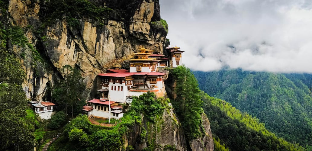
The Himalayan territory is also well-known for its many monasteries and fortresses or dzongs. With a physical geography of steep mountains, numerous streams, and valleys, connecting to isolated territories in the kingdom was of paramount importance for transmitting messages.
Origin and Decline of Trans Bhutan Trail:
The trail was a network of paths running east-west across Bhutan. It traces its history back to the 16th century, however, it is said to be much older.
Purpose of the ancient trail: An essential messenger route, it connected Bhutan’s fortresses across the kingdom, to help thwart foreign incursions. Garps or message carriers, travelled through the lengthy track at tremendous speed, often with little rest, carrying and delivering vital royal, administrative, or religious messages and mail, between dzongs.
As the trail was the only way to traverse the tiny kingdom, it was also used as a means of transportation. Additionally, pilgrims and Buddhist monks used the route to pay homage to the holiest temples from east to western Bhutan. Furthermore, it served as a pivotal trading route for traders, and often rice was bartered for silk, especially with India.
Ultimately, the route served as an important unifier and means of communication for Bhutan’s several provinces. Its role as a symbol of unity to fend off external invasions was pivotal in the nation’s birth in 1907. For several years after, it remained the only way to travel between the two ends of Bhutan.
Neglect and abandonment: Despite its glorious standing in the country’s past, it gradually fell into disrepair, and parts of it disappeared entirely. Bhutan’s attempt at modernisation in the 1960s led to extensive construction of roads across the country and gradually people switched from carts to cars. With the opening of the first national highway in 1962, the trail eventually went into disuse. Large sections of it had been incorporated into the new tarmacked network, and much of it vanished into forests.
Restoration and Opening of the Trail:
2018 saw a turning point when The King of Bhutan, Jigme Khesar Namgyel Wangchuck, announced plans to resurrect the former symbol of national unity. With the vision of a sustainable tourism project in mind, with minimal impact on the environment, he hoped to make the trail accessible to inspire locals and tourists alike to connect with the country’s far-flung communities.
The ambitious project was led by The Bhutan Canada Foundation, with support from the Bhutanese government. The foundation was formally established in 2009 to foster knowledge exchange, reinforce well-being and happiness across Bhutan, and maintain positive relations between the two nations, through sponsorship and partnership programs.
Repair: Restorative work on the trail commenced soon after the king’s announcement and local workers were positioned to complete the mammoth task of clearing and then rebuilding hundreds of kilometers of the trail,18 major bridges, and more than 10,000 steps. Along with this, interactive signposts with QR codes made from recycled material were placed at measured distances. These codes can be accessed to learn about the history of each slice of the trail. Repair of the historical route employed a workforce of over 900 people.
Inauguration: Bhutan opened its borders and welcomed tourists back, after the pandemic, in September 2022. One of the glorious key highlights was the launch and opening of the 403-kilometer-long Trans Bhutan trail, after nearly 60 decades of neglect.

The uniqueness of Trans Bhutan Trail:
Touted as one of the most majestic long-distance walks in the world, the Trans Bhutan trail runs from Haa – a jewelled paradise in the west – to Trashigang in the east – a crucial trade centre between Assam and Tibet. Snaking its way through the lofty Himalayas, the route traverses over 20 gewogs (villages) and temples, 4 dzongs, numerous mountain passes, bridges, and chortens (Buddhist shrines). Spanning over nearly 400 historic sites, the trail connects some of Bhutan’s most remote and beautiful sites.
It takes between 27-30 days to complete and can be walked, or biked. As with all treks, it’s an equal mix of easy to moderate and challenging. Treks can be customised from 4 to 8 to 15 days as well.
Places to see on Trans Bhutan Trail:
The Trans Bhutan Trail is a nature lovers’ paradise offering spectacular scenic views of deep valleys, sharp mountain peaks, rhododendron forests, and green rice paddies. It is home to several species of birds and endangered animals. Connecting varied villages, it also offers a rich slice of cultural history through exposure to multiple dialects, temples, and Bhutanese cuisine.
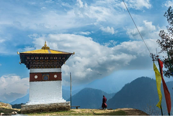
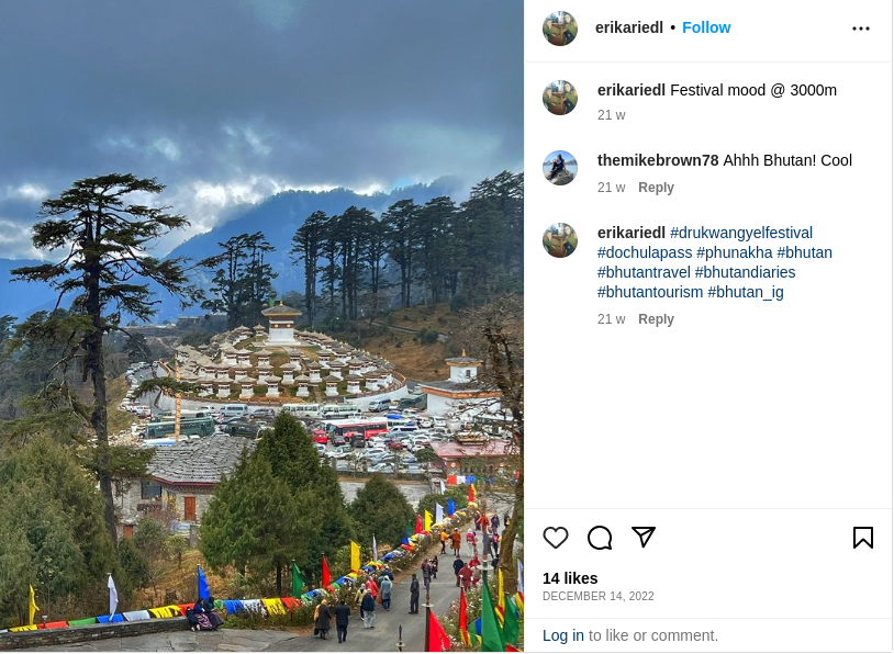
Dochula Pass: A beautiful mountain pass, Dochula Pass is located close to the capital, Thimphu. It is as stunning – offering panoramic views of the surrounding Himalayas – as it is historical. On a clear day, the massive Gangkar Puensem sitting at 23,000 ft, the highest unclimbed mountain in the world, can be seen from here.
The pass is now synonymous with the 108 Druk Wangyal Khang Zhang chortens, or shrines. Commissioned by the eldest Queen Mother of Bhutan, Ashi Dorji Wangmo Wangchuck, as a tribute for the valour of the Bhutanese soldiers who were martyred during the successful battle against Assamese insurgents in 2003, and to mark the victory of King Jigme Singye Wangchuck, the chortens can be easily spotted by their white and red colours. Encased by fir trees and situated on a hillock under the pass, the shrines have been built in three pyramidal layers, where all the chortens surround the main shrine. Tourists can participate here by hanging prayer flags to honour the gods.
A short trek from the chortens leads to eleven manmade meditation stone caves, also built to honour King Jigme Singye Wangchuck. Decorated with gods and goddesses, especially the druk, or dragon— Bhutan’s national symbol —the caves visually represent symbols of the king’s birthday.
Close to the Dochula Pass, lies the Druk Wangyal Lhakhang temple. Completed in 2008, again as a tribute to the king, the temple was constructed to celebrate 100 years of monarchy in Bhutan. Set against a green backdrop of thick forests, the temple is a blend of modern and traditional. Murals on the walls fuse ancient themes of Bhutanese history with contemporary paintings of monks with laptops and airplanes. An annual festival is held in December to commemorate the king’s heroic defeat against the Assamese insurgents, with storytelling dances and costumes.
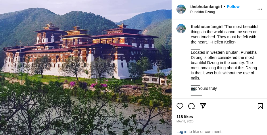
Punakha Dzong: 5000 feet above sea level, lies Punakha, the erstwhile capital of Bhutan. The first national assembly was hosted here in 1953. Two important rivers of Bhutan, Pho Chhu and Mo Chhu, meet here, and at their confluence sits the majestic and architecturally superior, Punakha Dzong, which is both the second-largest and second-oldest fortress in the kingdom. The exceedingly sacred relic, Rangjung Kharsapani, lies inside the dzong. The fortress also carries the preserved body of Zhabdrung Ngawang Namgyal, the founder of Bhutan and a revered spiritual leader who unified warring groups into one country.
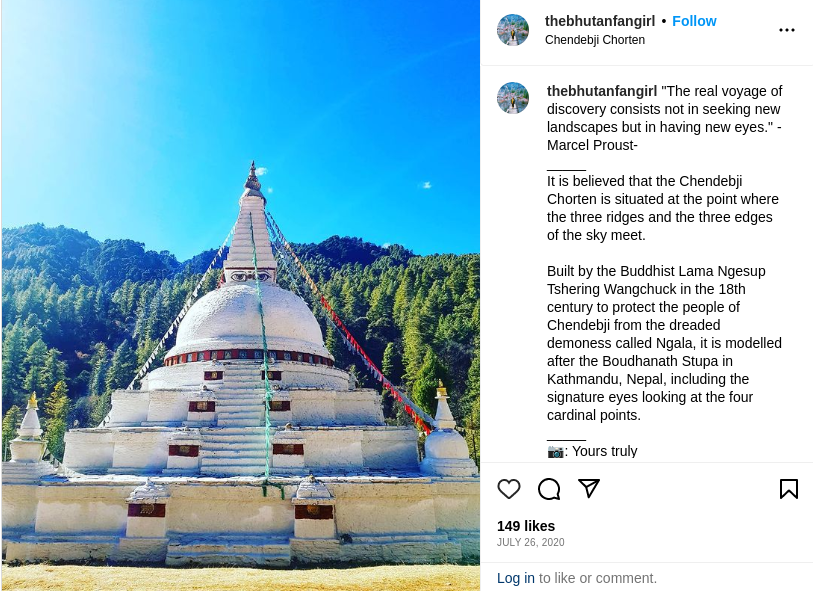
Chendebji Chorten
Modelled after the Boudhanath stupa in Nepal, with eyes painted on cardinal points on the four sides of the shrine, the 18th-century Chendebji chorten is one of the most important Buddhist sites in Bhutan. It was built by Lama Ngesup Tshering Wangchuk to ward off evil spirits. Legend has it that the shrine was built on the site where an evil spirit in the form of a giant serpent, was defeated. Another story about the sacred spot claims the shrine was built to crush a demoness who brought misfortune to the local people.
The Sambha Lhundrup Molam Chenmo festival is celebrated annually in the ninth month of the lunar calendar, attracting large crowds.
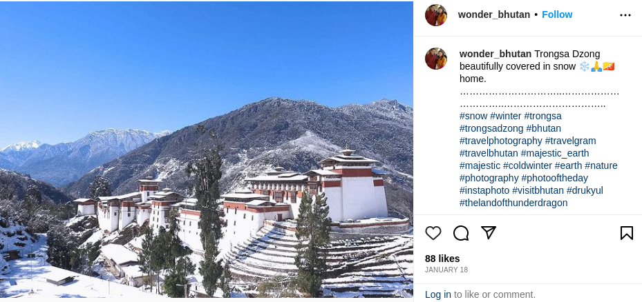
Trongsa Dzong and the Royal Heritage Museum: The town of Trongsa sits in the centre of the trail, surrounded by the scenic Black Mountains and Mangde Chu Valley. The Trongsa Dzong, overlooking the Mangde Chu River, is the largest fortress in Bhutan. Its exceptional location has often been described as “the most spectacularly sited dzong in Bhutan with a sheer drop to the south that often disappears into cloud and mist”.
The fortress was initially built as a small temple by Lama Nagi Wangchuk, in 1543 and was replaced as a dzong by his great-grandson in 1647. It was used for protection and was a nerve centre for trading. Several renovations, expansions, and repairs have taken place at the fortress over centuries. The Trongsa Dzong is also an important administrative building and is the headquarters of the government of the district.
The Royal Heritage Museum is housed in the tower built above the dzong. The tower was built to serve as a lookout to shield Trongsa Dzong from external attacks. It was converted into a national museum in 2008. Today, the museum houses several religious and royal artifacts.
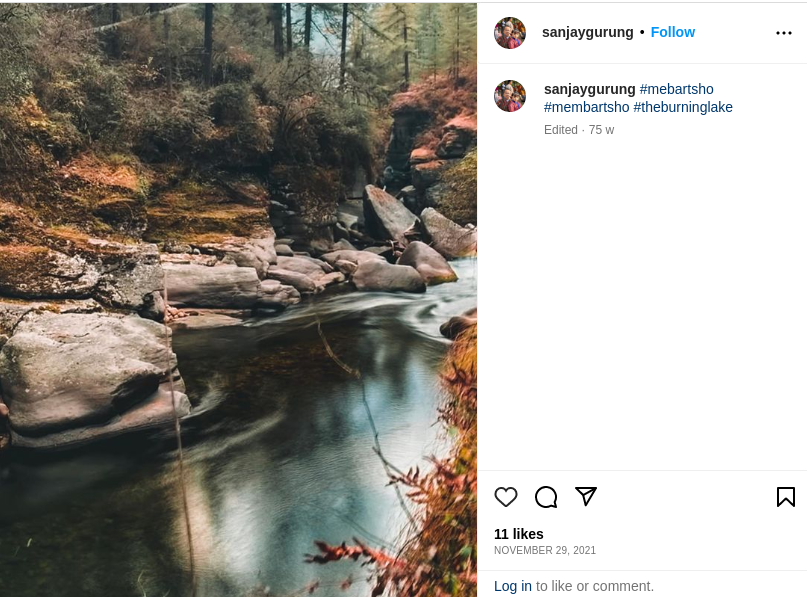
Membartsho: Situated in the Tang Valley and often referred to as the ‘Burning Lake’, Membartsho is considered to be one of the holiest sites in Bhutan. Residents believe that the revered Buddhist saint Pema Lingpa jumped into the lake with a lit lamp after getting a dream of a treasure buried by Guru Rimpoche, in the water. Disproving locals he emerged from the lake with a scroll, chest and the lamp still lit.
The lake is renowned for its beauty, tranquility, and spiritual significance. Pema Lingpa had also prophesied about a centre for learning for women in the Tang Valley. Pema Choling Shedra, the first Buddhist College for women in Bhutan, was established in 2001, to increase opportunities for Bhutanese girls by providing basic and higher education in Buddhist philosophy for nuns.
The most memorable part of the trail, however, lies in the warm hospitality of the local people. The populace in isolated areas, especially the older generation, reminisces about the old days on the trail and is elated to see tourists and younger Bhutanese navigating the trail to learn more about the history and culture of the ancient country. They are storehouses of ancient folk tales and traditions and legends, narrating many a fascinating story!
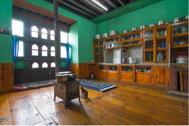
Local farmers happily serve tourists traditional meals in their homes of dried yak, cardamom-laden curries, and ara rice wine. Some even offer an elaborate cooking demonstration, with popular dishes of Ema Datshi- made from hot chilli peppers and cheese- and Kewa Datshi, a gravy made from potatoes, chiles, and cheese.
Flora and Fauna
Bhutan’s constitution states that over 60 percent of the country must be always covered in forest. The Trans Bhutan Trail is one of the world’s most biodiverse areas, with over 560 new species introduced since 2009. Throughout the trail, one can marvel at the forest canopy of rhododendron, oak, and cypress trees, interspersed with rice paddies.
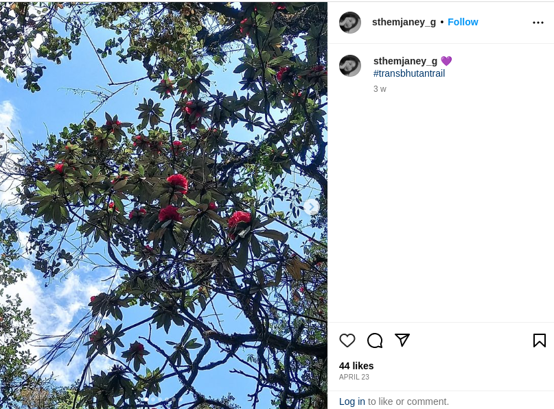
At Dochula Pass especially, the Royal Botanical Park forms a biological corridor of 47 square miles. Numerous species of ferns, magnolia, and birch are planted here. After the Losar festival, marking the Bhutanese new year, rows upon rows of rhododendron and Daphne flowers can be seen in full bloom. The park is home to over 46 species of birds, such as monal and blood pheasants, and is a popular bird-watching site. There are over 20 animal species which include musk deer, tiger, leopard, red panda, and the leopard.
Reaching Bhutan and Accommodation:
Indian nationals visiting Bhutan do not require a visa, however, they are required to carry either a passport or a voter ID, along with an entry permit which can be obtained online. There is also a small Sustainable Development Fee of INR 1,200 per adult per night.
Flights can be booked only through the official website of Bhutan’s national airline, Druk Air. Paro is the only international airport and has connecting flights from Delhi, Kolkata, Bagdogra, Guwahati, and Mumbai.
Lodging: Housing along the route includes a huge range of basic lodges, campsites, homestays, and luxury hotels.
Mendrelgang Homestay in Punakha is a popular choice offering traditional food. The heritage farm provides an opportunity for guests to learn about rural Bhutanese life. It costs around INR 2000 per night.
For ultimate extravagance, the Le Meridien Paro Riverfront costs INR 50,000 per night in peak season.
A popular alternative offered by tour operators is ‘signature camping’ – a happy median where campsites lay out calming hot stone baths, showers with hot water, and tents with beds.
Best Time to Visit:
Although the trail is open all year long, March to May (blossom season for the rhododendrons) and September to November (for clearer skies), are usually the best times for the hike. Since the climate is variable due to the fluctuating terrain, the walk can be undertaken in any month depending on which sector of the trail the visitor chooses to explore.
However, the key is to be well-equipped with a good pair of hiking boots and be aware of leeches in the rainy season. Bears also pose a threat in the forests and it is strongly recommended to take a guide for the entire duration of the trek. Additionally, the guides can communicate with the locals and also curate individual experiences.
Sustainable Tourism:
Bhutan’s leadership expects the country to serve as a blueprint for environmental responsibility to be the only carbon-negative country in the world. The trail is expected to become part of the national curriculum, with children going on expeditions to explore local plants and animals. Going forward, as part of a national service program, everyone under the age of 18 will be required to work and walk along the trail. There will be incentives for certificates and medals for those who cover the entire length.
The trail also contributes to maintaining livelihoods for local communities, preserving their traditional culture, and shielding delicate ecosystems.
Moreover, the Forestry Commission plants a tree for every person who uses the trail. Trail marker posts are manufactured from recycled plastics, and bridges have been built using responsibly-sourced timber. There are zero single-use plastics on the trail journeys.
The Trans Bhutan trail’s journey on foot offers a beautiful chunk of Bhutanese heritage. It is not only about getting closer to nature but, also about travelling at a leisurely pace to hear people’s stories. Culture is best understood through the individuals who live it, and Offbeat Tracks will tailor the finest programme for you to experience the majesty of the Trans Bhutan Trail.